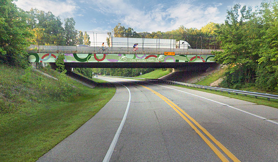
When the Michigan Department of Transportation (MDOT) built the I-275 highway as a 40-mile connector through Wayne, Oakland, and Monroe Counties in the 1970s, including a trail parallel to the highway was a visionary, multimodal achievement. The 24.8-mile section that traverses heavily populated areas of western Wayne County is known as the I-275 Metro Trail. Declining trail conditions and low use have the MDOT Metro Region strategizing about how to rehabilitate the trail to better connect communities along the route and enhance the regional trails network in Southeast Michigan. Wade Trim completed the I-275 Metro Trail Assessment and Recommendations Study to evaluate the trail and develop recommendations to improve conditions and pedestrian and bicyclist safety, and increase overall trail use.
The study began with an assessment of the trail’s existing conditions. The Wade Trim and LivingLAB project team walked, biked, and drove the trail using GPS and GIS technology to assess pavement condition, drainage issues, visibility, connections, structure locations, road crossings, signage, fence types, and the general user experience. Data was recorded on handheld tablets and input directly into an ArcGIS online database. In addition, all major intersection trail crossings, including signalized and mid-block locations, were reviewed for safety and operations. Field data was combined with existing aerial images, MDOT data, and community resources to create a comprehensive inventory of the trail.
Key findings of the assessment were evaluated and prioritized to develop proposed recommendations for the trail’s continued improvement. Recommendations fall into a wide variety of categories including trail surface, drainage, structural, regulatory and non-regulatory signage, and road crossings, as well as general recommendations applied to the entire trail. Recommendations for improving safety as well as pedestrian and vehicular interaction include pedestrian signal locations, reconfiguration of median refuge areas, ADA ramps, signal warrant analysis for HAWK signals, and upgrades to pedestrian scale lighting, pavement markings, and signs. In addition, development of a signage and wayfinding design manual is encouraged to enhance the Metro Trail’s branding and aesthetics with creative elements such as underpass and overpass murals.
The project team worked closely with key stakeholders including the Michigan Trails and Greenways Alliance, Friends of the I-275 Metro Trail, Wayne County Parks, Wayne County Road Commission, Huron-Clinton Metroparks, and communities that border the trail. Stakeholder feedback was used to develop and refine the recommendations, identify priorities, and build support for project implementation. An analysis of funding opportunities and resources to support trail improvements was provided and a 2022 Ralph C. Wilson Maintenance Fund grant application was developed and submitted to address at-grade road crossings.